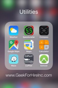
I got our first GPS way back in 2005. (Way before smartphones and Navigation Apps!) It was the perfect gift for Chris so that he could easily find his way to our customers homes and businesses. In the past ten years, GPS and mobile navigation in general has changed tremendously. Now, Smartphone apps include traffic problems, construction detours, and multiple alternate routes. It’s nice to be out there with your iPhone, Android, or other smartphone, so you’re able to get where you’re going with minimal issues.
Contents
My favorite app is the one that came with my iPhone. It’s simply called “Maps”, so I use it on all of my road trips. There have been a few times when it has steered me wrong, but mostly it is right on. One issue I have with it though, is that it is a battery drainer. So for long road trips, I keep my phone plugged in and charging when I have the Map app running. Another issue is that it doesn’t allow me to take a prettier back road without telling me to “make a U-Turn”!
Other Navigation apps that people like include:
Google Maps
This is what I use at my desk computer to help plan road trips. Firstly, it synchronizes nicely with Google Calendar. Secondly, I like that it shows me local businesses who have a Google listing. However, the smartphone app doesn’t show accidents or construction, so I don’t use it on the road. Available for iPhone, Android
Waze
This is a highly rated app and not only gives you info on Traffic, but also upcoming Hazards, as well as Gas Prices, etc. When I downloaded it I noticed some problems right away. First of all, it won’t give you directions to a location more than 999 miles away. Also, you have to drive at least 100 miles with Waze on before it will tell you where the cheap gas is. So, while others rate Waze highly, it gets a pass from me! Available for iPhone Android Windows
Komoot
I wish I’d known about this app before my kids started and finished the Appalachian Trail. Techlicious writes “This navigation app from a German startup covers an exhaustive range of North American bike paths and mountain trails, with topographic maps for hiking and biking routes near you. Its database is built from open-source info as well as user-submitted data to suggest trails for different fitness levels.” Available for Android & iOS
CoPilot
I haven’t used Co-Pilot, but I like that you can download your map ahead of time. Consequently, you’ll save on data. Techlicious writes “A full-fat nav app like CoPilot is a good idea if you’re overseas, for instance, and don’t want to use roaming data or depend on Wi-Fi stops to update Google Maps.” Available from copilotgps.com
Which of these apps do you use? Are there others that that I didn’t include? Let me know your favorites in the comments below!
Chris Eddy of Geek For Hire, Inc. has been providing computer service to families and small businesses with Mac’s and PC’s for the past fifteen years. His company is highly rated by both the BBB (Better Business Bureau) and by Angie’s List. You can find more on our website. Geek For Hire, Inc. provides onsite service (Tier 3) to the Denver / Boulder / Front Range area as well as remote service throughout North America.
We’ve been using Amazon Prime for the past few years. We like the free 2-3 day shipping and the online streaming. I haven’t tried the Kindle lending library yet. Maybe I’ll try that next! Prime is normally $99/year, but you can try it for 30 day for free by clicking on this link: Try Amazon Prime 30-Day Free Trial (Yes, we’ll get a small commission when you sign up.)